Henry Cowell Redwoods State Park, CA
I don’t know how many times I have sat down to write about Henry Cowell State Park. It has become one of my special places and a must-visit for every guest we have. After every trip, I vow to complete this entry and every time it is left abandoned as I struggle to capture the spirit as well as include our latest adventure in this corner of the world.
 I was blessed to discover this awesome park. Last Spring Highway 1 to Big Sur washed out and was closed for a couple months. At the time I was really disappointed, but looking for other hiking opportunities, I ordered a Santa Cruz Mountain Trail Book and learned of the these redwood covered mountains. Just outside of Santa Cruz, this park and the town of Felton offer ample opportunities to explore my beloved trees. The easiest and most spectacular hike is the Redwood Grove Trail, an .8 mile hike through an old Redwood Grove boasting 1400-1800 year old trees. Every time I enter this grove a calmness settles in me. The crowns of the glorious trees tower above. The duff covered path is soft beneath my feet. Large clovers that taste like granny smith apples provide an emerald carpet around the trees. Some of the trees display the scars of past fires reminding me of their strength and perseverance. I pet the now familiar creatures saying hello as the now appear to me as old friends. The tallest tree in the grove stands soars as high as the Statue of Liberty. By slowly walking around the base, alternating by looking up to the top and examining its enormous width, I try to comprehend its size. Every time I do this I am no less amazed than my first visit.
 My absolute favorite tree is the Freemont tree and I always pack a flashlight just for this tree (although I recently discovered you can check out flashlights from the visitor center). A small opening, like that of an elfin door in a fairy tale, allows one to crawl inside the giant and study its girth from the inside out. Once inside even the tallest man can stand comfortably with several of his friends. Burnt bark explains how the tree was once hollowed by a fire. A shelf had been carved into the bark at some distant time perhaps when Captain Freemont himself camped here. It is impossible to venture inside this redwood and not hear childhood whispering at my soul. Reminding me of those days when living in a tree in a magical forest would be a dream come true.
 This short walk always grounds me and awakens my appreciation for life on this earth. Yet I love continuing further into this park. It’s always fun to walk across a hundred year old rail bridge. Other trails wander to the Cathedral Redwoods Old Grove then to a wonderful swimming hole which is the perfect spot for a picnic with an old friend. A hike up the mountain to the observation deck reveals views all the way to Monterey. Next door to the park, Roaring Camp Railroad ventures over old trestles, up the mountain and through the woods on an original logging train. At the top in another old grove, the ancient tour guides gives a conservation speech so impassioned that I have to resist from enveloping him in a giant bear hug. For a different perspective, we spent one afternoon zip-lining our way through a Redwood Canopy Tour at Mount Hernon. Here I had my only opportunity to be in the trees themselves, marveling in their size by looking down instead of up.
There are so many ways to enjoy this area, truly something for everyone. I love this area. And I know I am not the only one who feels this way. One day driving just outside the park, I passed a man who had set up his full drum set on the side of the road was playing his soul out. And although it’s not how I would celebrate the beauty of Henry Cowell, I respected the passion as I felt it myself.
- Park Website: https://www.parks.ca.gov/?page_id=546
- Redwood Canopy Tours: http://mounthermonadventures.com/adventures/
- Roaring Camp Railroads: http://www.roaringcamp.com/


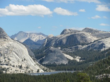 Huge granite plutons bulged high above the road. We pulled into the overlook viewing tall Pines growing from more giant boulders. Areas of the bedrock had been polished smooth leaving evidence that this was all once covered by glaciers. Beyond the trees and rocks was Yosemite Valley and the vista offered another view of Half Dome; this vantage point showcasing its rounded side. To the east, Tenaya Lake’s deep blue water shimmered below the three rounded mountains framing all but the western side.
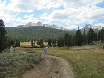 A few miles down the road, the Tuolumne Meadow Visitor Center recommended we walk the Soda Spring Trail and then head east leaving the park to see Mono Lake. Named for the carbonated water that bubbles out of a spring, the Soda Springs hike was flat, short and tranquil. We had escaped the masses of the Yosemite Valley. The meadow was flanked by domes and peaks. The northern sides containing small glaciers protected from the warm sun. I could imagine vast herds of moose and elk once roaming the serene meadows and drinking from the meadow.
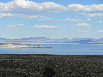 Feeling refreshed from the mountain air and the bit of exercise, we continued driving to Mono Lake. As we climbed higher in the Sierras we passed more beautiful lakes and ice-capped mountains. Just shy of 10,000 feet, we exited the park at Tioga Pass and began the descent down the rain shadow side of the mountains. Examining the semi-arid environment, I questioned if this was the correct choice. I love forests much more than the desert. Mike and I decided that since we had made the trip maybe we could at least find a place in Mono Lake to swim. I knew that it had once been a volcano that had exploded, so I figured the water had to be warmer than the snowmelt river we swam in yesterday.
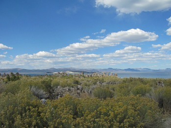
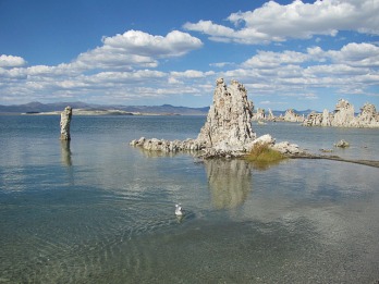 A quick trip in the Mono Lake Visitor Center and we were directed to the South Tufa area of Mono Lake for sightseeing and swimming. Being a geographer, I am a bit ashamed to admit that I had no knowledge about tufa. Apparently tufa is a limestone rock formation that forms when springs with high calcium levels mix with carbonate-rich lake water. Over hundreds of years, towers, similar to stalagmites in caves, form underwater. In the middle of the last century, new water policies resulted in water that normally flows into Mono Lake being diverted to large population centers. As a result, the water level in Mono Lake receded revealing the tufa. Further exacerbating this issue, the lake lies in an arid region with high rates of evaporation. Every day more water is lost into the atmosphere. Besides the unusual tufa landscape, the evaporation causes the lake to be 2.5 times saltier than the ocean.
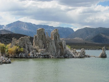 As soon as we left the parking lot, we began passing tufa surrounded by desert scrub. We were still at least 200 yards from the water itself. The tufa disclosing how much was once underwater. We reached the shore; it was unlike anything I have ever seen before. I could’ve been on the moon. I looked at the desert landscape surrounding the large lake. Despite the warm temperatures where I was standing, glaciers clung to the sides of the western mountains. Over 300 miles from the ocean, seagulls dipped down into the sapphire water.
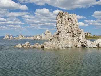


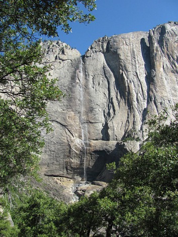 Leaving the Central Coast and heading east we watched the temperature rise to three digits. Luckily once we ascended into higher elevations, the temperatures dropped a little. As we entered the park and Yosemite Valley, sheer granite canyon walls surrounded us and the occasional waterfall cascaded down. We drove deeper into the valley, Mike pulled over so we could admire the view of Yosemite Falls, the tallest waterfall in North America.
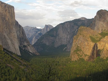 We next drove up to Tunnel View. A crowd was gathered at the overlook that provided a gorgeous view of the Valley. I noticed a sign for a 1.5 hike uphill to Inspiration Point and suggested we explore that. Five minutes from the overlook, the views were more spectacular than the overlook without any people. We continued climbing up the mountain until we reached a backcountry campground. We soon realized that the campground was in fact Inspiration Point, which was disappointing. We turned around stopping about fifty feet above the overlook. The sun was sinking lower into the sky behind us casting gold and pink hues over the Valley, Half Dome, Bridalveil Falls and El Capitan. This spot was much more inspiring.
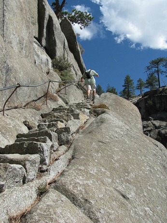 Thursday morning we woke to vibrant sunny skies. We decided to begin the day with a 7.2 mile hike with a 2700 foot climb up to the top of Yosemite Falls. Immediately the hike began with switchbacks and I knew we were in for a challenge. Luckily the trail was shaded, but I still ditched my long sleeve shirt in the first fifteen minutes. Mike was determined to keep a good pace, but after thirty minutes I needed to take a break and catch my breath. The trail had begun to lose its tree cover and the sun was shining directly on us. As soon as we resumed walking, the trail began to head downhill. I cursed it as I did not want to lose any of the elevation gained. We rounded the corner of the mountain to see the first views of Upper Yosemite Falls from the trail. Looking up, I knew we still had a very long way to go.
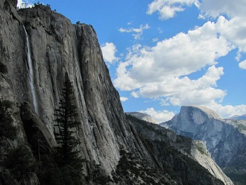 The last mile up was rough. The trail continued to get steeper and the sun continued to get hotter. As we approached the top, we needed a thirty-second-catch-our breath-break every five minutes. I kept looking up at the trees clinging to the edges of the cliff longing to be down climbing and sitting in the shade. Almost three hours later, we finally reached the top. We walked another ten minutes and descended a rocky staircase to the top of the falls. Looking upstream, the water flowed down two small falls separated by a refreshingly lovely pool before plummeting over the edge and flowing over 2000 feet to the valley floor. Nearby we found some trees to rest under and enjoy the vistas of Half Dome and Yosemite Valley.
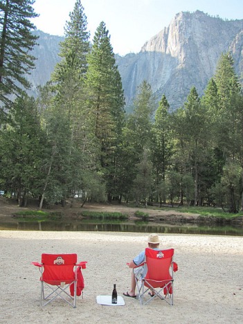 Although we had some snacks at the top of the falls, we were pretty hungry. A picnic with some noshing sounded perfect and we stopped at Yosemite Village for supplies. The rugged hike was a sharp contrast to the full grocery store. I was not prepared for the amount of development in the village as a whole or the size of the grocery store. I couldn’t help but try to think of what I could cook over the campfire with curry paste but the reality was I wanted out of the air-conditioned food extravaganza. We quickly selected some crackers, salami, herb goat cheese and blackberries. Back at Housekeeping Camp, we changed into our swim suits and grabbed a bottle of wine, towels and chairs.
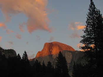 I raced back to shore. Mike, who would love to be in a Polar Bear Swim Club, was laughing hysterically. He jumped in and happily swam around while I thawed out in the late afternoon sun.


 The Rocky Ridge trail is a brutal 1700 foot climb in 2 miles. With each step, I questioned why I was doing this. My calves began to ache earlier than expected and my lungs begged for a break. The sun beat down; it was much hotter than the previous times I’ve climbed this mountain. Luckily incredible views of the Pacific Coast provided great excuses to stop, catch my breath, and take in the scenery. Sapphire waves lapped at marine cliffs. Barking sea lions punctuated the fresh air.
 A passerby informed me she spotted a baby rattlesnake further up the trail. Again I questioned my decision but kept going. I told myself to just put one foot in front of the other. I climbed above the hawks looking down at a cloud clinging to a smaller mountain. At 1400 feet above sea level, a bench rewards the tired climber with a needed break. I sat for ten minutes letting the blood drain from my head. I wondered if I should call it quits as I looked up at the last few hundred feet. I decided to power through and in another ten minutes I had reached the summit. To the east, the Santa Lucia Mountains bordered Carmel Valley. To the northwest, the coastlines of Carmel Highlands and Point Lobos. To the south the distant trailhead was barely visible along the now tiny Highway 1. I took a deep breath and felt the rush of endorphins.

 A couple miles in we reached the back country campground. Another mile or so, we discovered an old car down in a narrow ravine. From photos, my husband later identified it as a 1948 Ford. The car was upright, but the front and top were smashed in from flipping over. The rubber from the back tire had blown over the rear wheel. The interior was gone and plants grew in the car and the engine. Bree and I looked up and around wondering where the road had once been and how and when this car had ended up here. What happened to the passengers? How long had this car lay here?
 The trail continued through an overgrown and more densely wooded section. Before long we started climbing down. The few gaps in the trees revealed amazing views of the Santa Cruz mountains as well as the depth of the substantial canyon we were descending into. I tried to enjoy the hike down, but with every step I couldn’t help but wonder how miserable the long climb up would be.
 After finishing our wonderful hike, we toured through the car camping section. It was early evening on a Friday. Families were setting up tents in the lovely redwood dotted campsites. The sounds of children playing echoed from the creek below. Unfortunately, this campground only has a few more months before is closes in November and the whole park closes in July 2012. What will happen to it? No more campgrounds packed with families enjoying quality time away from the TV and computer. Is it even legal to close these parks that were bequeathed to the public? Is it even possible to absolutely close them? Is there a way to protect the park from people coming in and trashing this sacred spot? Or will the trails simply grow over and the beauty of this place be forgotten? And this is just one natural treasure on a list of seventy. It makes me so sad to think that these places, our state parks, may simply be lost.

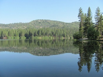 We packed up our camp site in King’s Canyon National Park then began the beautiful though somewhat long drive to Sequoia National Park. In the higher mountain peaks of Sequoia National Forest, Mike stopped for a morning dip in Hume Lake. Being a Saturday morning, several fishermen lined the lake. The swimming area was still largely deserted as the morning temperatures hung in the 60s. Trying to respect the tranquility, Mike swam stealthy while I enjoyed the scenery and thought about the plan for the day. Mike had a lot of homework he needed to finish before Monday, so he wanted to head back to Monterey by mid-afternoon. I knew I had to choose carefully as we were only going to see a few highlights in this national park.
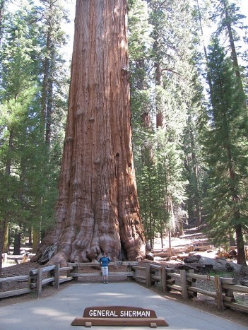 The General Sherman Tree and the Congress Loop were “must-dos”, so we began exploring in the Giant Forest section of the park. The parking lot at the trailhead was filling up fast, but we got a spot and began the short trek down to the largest living creature on Earth, the General Sherman Tree. As we walked I looked for differences between the closely related Redwoods and the Sequoias. It is often hard to gauge the height of tress that grow as high as city buildings. I knew that Coastal Redwoods are the tallest trees on the planet, and the Sequoias are the biggest trees measured in volume. However, some of these trees were as tall as some Redwoods. As I gazed up, I noticed that their upper branches were much thicker than those on Redwoods. An overlook revealed the General Sherman. Around 2300 years old, 275 feet tall and over 100 feet around, this was a massive tree. A lot of the surrounding forest appeared to be cleared, so that one could attempt to comprehend the true size. We continued down to the base of the trunk. Yet even walking around the tree it was hard to grasp the extent of this colossal creature.
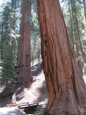 The General Sherman Trail intersected the 2 mile Congress Trail. This was also a paved trail and with the crowds at the General Sherman tree I expected this loop to be busy too. Fortunately, fewer people were continuing past the main attraction. The loop traveled through the center of the Giant Forest with impressive groves of the amazing trees. As this was the second national park established, several of the trees paid homage to those in Washington DC. The President was an impressive specimen as were the House and Senate Groves. Breaks in the trees along the southern edge of the trail revealed views of the surrounding Sierra Nevada Mountain Peaks reminding us that we were hiking at 7000 feet. Towards the end of the loop, we walked under part of an enormous fallen tree that is said to have crashed decades ago, waking a sleeping ranger 2 miles away.
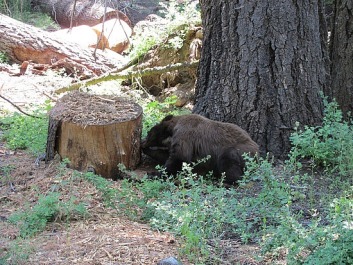 As we were driving away from the General Sherman parking lot, I spotted a small bear on the side of the road. Mike stopped the car about ten feet in front of the animal. “He’s cute,” Mike began then we both jumped a little as the bear ripped off half the bark of a tree truck in one swoop. Luckily he was not that interested in us as he appeared to scavenge the stump for bugs. It was pretty thrilling to see the bear so close up, but I was also very relieved to be in the car. When it did appear a bit more curious about us, we decided it was time to quickly move along.
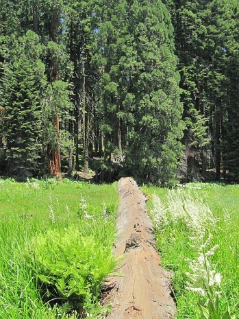 On weekend days the road to Crescent Meadow and the Drive-Thru tree are closed. Visitors either need to hike into these places or take the shuttle bus. If we had known just how crowded this area of the park would be, we would have left our car in the General Sherman lot and taken the trail. Hundreds of people flocked around the Giant Forest Museum. Wanting to get away from the herds as quickly as possible, Mike and I hopped on the first shuttle. Most of the people on the bus exited at Moro Rock, so we continued on. A large family group got off at the Crescent Meadow Trail head, but other than that it was us. The trail wound around the Sequoia and Pine rimmed meadow. Large fallen trees dissected the emerald meadow where the last of the wildflowers lingered. A fair amount of people were visiting the area and it we had to pass several trunks before we found an empty one. Using the fallen tree as a bridge we ambled across the trunk into the center of the field. It was a great place for a snack to soak up the scenery and watch butterflies flit about.


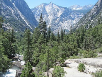 Sequoia and King’s Canyon National Park are adjacent to one another and it took us almost four hours to reach the park gate. The ranger informed us that the camping in Sequoia was full so we decided to camp in the Cedar Grove area of King’s Canyon. We headed over the sequoia covered ridge peaking at around 7000 feet. The narrow road wound along steep and jagged cliffs as we made our way down the back side of the mountain and along the sides of King’s Canyon. The sun was rapidly lowering in the sky highlighting the majestic vistas of the glacially carved landscape. I glimpsed waterfalls through the pine trees; the water eventually flowing to the surging King’s River that cut its way through the narrow canyon floor. An hour later the road ended in the Cedar Grove area. Twilight was settling in as we tried to select a good camping spot. We finally decided on a large site in the Sheep Creek campground. Although several large pines and sequoias towered around the area, I was a little disappointed that the campground was not more densely forested. Then I looked up. The first stars of the evening were appearing directly above. The shadows of the tall trees bordered the perfect outlook of the night sky. Once our tent was set up and the camp fire crackling, we nestled around the fire watching the sky brighten with stars until there was almost more light than darkness.
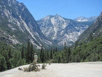 The next morning we woke to see the campground in daylight. Despite our 4600 foot elevation, the cliffs of the canyon loomed above us. We decided to stay in King’s Canyon for the day then explore Sequoia National Park on Saturday. A park ranger recommended hiking to Mist Falls, a nine mile round trip. Despite the beautiful scenery, the first steps of the trail were sandy causing it to be more difficult to walk on. The wooded area of the trail head opened to meadows allowing the sun to beat down on us. Luckily after a mile or so, more trees lined and shaded the trail and pine needles were a welcome relief to my calves. The chilly green water of the turbulent King’s River offered lower temperatures especially in areas where large boulders dotted the trail trapping in the cooler air. Rocky stairs appeared ahead and we climbed up above the tree line onto granite boulders. Sweating, I looked up the canyon walls and beyond to the mountain tops. Small patches of snow still remained in the cirques above. The roar of the water increased and water toppled over the side of a giant rock. We questioned if that could be Mist Falls, but did not think we had walked far enough. Another twenty minutes later, the aptly named Mist Falls appeared.
 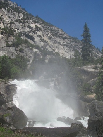 At least 100 feet from the base, the spray hit our faces as we walked to the edge of the water. It felt amazing. A lot of people were sitting in the area enjoying their lunch. We continued climbing up to the top. Smooth rocks provided a perfect sitting and vantage point. Snacking on apples, we spotted a waterfall high up on the canyon walls, tumbling through a narrow corridor. The break from hiking was nice, but we were still hot. On the way down, we walked back into the mist and spent a couple minutes enjoying the refreshing droplets. I was happier and feeling better than before we started as we retraced our steps back to the trail head.
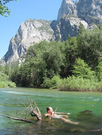 Mike looked for a good spot to get in and also get out. There did not seem to be a lot of options. He finally just dove in. The current was much stronger than he anticipated and he grabbed onto a branch in the water to stay in place. It did not take long in the nippy water for Mike to cool down. He dried off and we hit the Zumwalt Meadow trail, a 1.5 mile loop that had also been suggested. We followed the river than headed across a footbridge that resembled a miniature Golden Gate. We entered a small forest than followed the trail along a wooden path raised about a foot above the meadow. The aquamarine river flowed between the trees and the emerald green pasture. The gorgeous setting was backdropped by huge granite mountains. The trail skirted the perimeter of the meadow before ending at the base of the southern mountains. Here the trail was flanked with massive boulders and riddled with smaller ones that often required climbing. The rocks were visible reminders that glaciers had once carved this canyon, plucking these rocks out of the mountains as they advanced and depositing them as they melted.


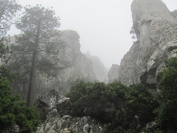 It was chilly as we headed through the woods. Luckily the path began at a lower incline, but soon we were walking uphill through the damp cool air. “I’m not sure if I want to go all the way up,” Mike panted explaining how he was feeling drained from the previous day’s driving if not also from the two week trip. “Let’s just see how we feel and play it by ear.” I suggested. The climb up at least eliminated the chill as our heart rates and breathing increased. We crossed the Pacific Crest Trail and kept heading up the side of the mountain. I suspect Mike was about to throw in the towel when a break in the trees and a slight break in the clouds revealed the granite crags and spires of our destination. We continued up and up. As we approached our destination, all but a few conifers remained and the trail changed from soil and pine needles to rocks and small boulders.
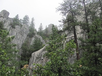 The clouds swirled around the giant plutons adding a mystical and almost dream-like quality as we navigated our way up and over the rocky path. The crags did resemble a medieval castle bordered by tall granite towers. I don’t know if it was the fog or the fatigue that contributed to the sense that we were wandering through our own fairy tale where a dragon or a knight may appear needing to be slain. The end of the trail was not marked, so we continued exploring the large boulders at the tops of the Crags. As the rocks became slickers and steeper, we determined we had definitely gone beyond our goal. As we retraced our steps, the clouds began to dissipate from around the crags. However, they still clung to the surrounding mountaintops. We could see more than earlier and enough to see that on a clear day, the views must be incredible. I couldn’t help but be disappointed that the weather was not cooperating. On a positive note, we had made it to the top, a mere 2200 foot climb to the spectacular Castle Dome. And a six mile hike is a great accomplishment especially on a yucky day when all you want to do is stay in bed.

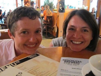 Tripping over each other’s words, Natalie and I picked up where we left off 10 years ago. We met Mike at Deschutes Brewery and grabbed a table in the bar area. Natalie and I immediately began making fun of the shape of the table. Designed to allow for extra counter space, it was a small round bar height table with an even smaller table-top stacked at eye level. We reverted back to the silliness we possessed at age sixteen resting our chins on the table discussing how this could make for a very awkward first date. We were still giggling when the waitress came to take our orders. Mike had already sampled the beer and he ordered a Fresh Squeezed IPA while Natalie and I each got a glass of wine. Munching on fresh soft pretzels, beer nuts and paprika fries, Natalie and I caught up and she and Mike got to know each other a bit. We asked her the truth about the weather and she disappointed us by explaining that it does in fact rain at least nine months a year. I sighed, “I guess we won’t be living in the same town anytime soon.”
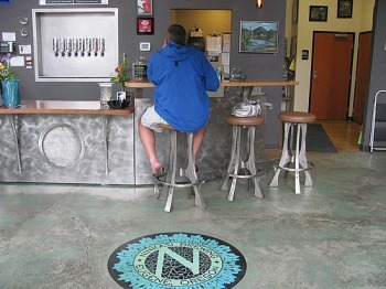 We woke Tuesday morning to the sound of rain. We had originally planned on spending some time in Eugene then camping somewhere in Southern Oregon. With a couple of exceptions, most of what we wanted to do involved outside activities. Yet rain was predicted from Portland into Northern California. We got in the car choosing to figure it out along the way. After some pizza and a short walk around the University of Oregon, we went to Ninkasi Brewing Company’s Tasting Room. They definitely had the coolest set up we had seen yet. Again we wished for a sunny day as we viewed their awesome patio. While Mike enjoyed a pint of Oatis Oatmeal Stout, we decided that we may as well drive back in to California tonight as the weather looked nasty for the next 24 hours.
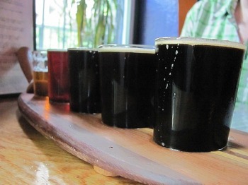 Before hitting the California state line, we stopped at Caldera Brewing Company in Ashland. Located on appropriately named Water Street, the building lay between the street and a creek that the day’s rain had turned into a torrent. While Mike examined the beer list, I watched water rage past the windows, flowing higher than the floor of the simple tap house. Mike was delighted that they made several Porters and Stouts, selecting a few to try along with their Dry Hop Orange and Ashland Amber. Mike thought all the beers were amazing and insisted I have a sip of the Mogli. We agreed that the chocolate, bourbon, oak-aged Imperial Porter might be the best beer we both have ever had. Luckily they sold it by the bottle, so we bought several to take home. With a new favorite brewery on the list, we waved good-bye to Oregon.